


Power To Control Weather In The Hands Of Florida Farmers
 October 20, 2016
 The Florida Automated Weather Network (FAWN), a program of UF/IFAS, recently developed and deployed to its digital platform several interactive tools that can be useful not only to agricultural users, but also to the general public.
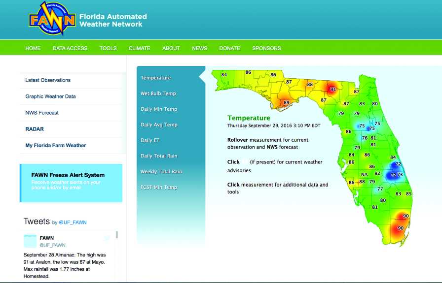
For example, visitors to Fawn.ifas.ufl.edu can easily access a current measurement, a 36-hour National Weather Service (NWS) forecast, and any applicable NWS watches/warnings for a station by simply placing the mouse cursor over a station on the home page map. Radar images and animations also are available with a mouse click.
Each station web page now provides a new look and feel, as well as new station-specific products. For example, a NWS graphic forecast of several variables — including wet bulb temperature — is available, as well as station location information, including photos, a map, and current radar images.
A major revision to this page includes how the cold protection tools are displayed. Previously, users were required to navigate through each tool, selecting stations along the way. Now, with one click, users can view all the tools as they apply to one station right from the station page. These enhancements make it much easier for users to access station-specific information and tools without having to visit multiple pages.

In 2011, FAWN began a collaborative project with the Florida Department of Agriculture and Consumer Services (FDACS) Office of Agricultural Water Policy titled “My Florida Farm Weather.” This high-resolution farm based weather station network provides growers with site-specific weather data that can be used to maximize water use for irrigation and cold protection. Each weather station measures air and dew point temperatures, wind speed and direction, relative humidity, and rainfall amount. Data points are collected every 15 minutes and displayed on a web page.
FAWN also developed an app for iPhone and Android platforms that allows users to view data and decision-making tools on a smartphone. One unique feature of the app is that it allows the user to manually submit a temperature from any location and to view that temperature on the map with the existing data.
This is useful for growers that might want to travel around their property with a handheld thermometer, submit measured values, and then view the map in an effort to better understand the conditions overall and/or in specific locations. Other app features include data graphs, map customizations, cold protection tools, and notifications. Since the program began, there have been approximately 180 weather stations deployed.
In addition to the website and app, users can stay up to date on station issues, upcoming events, and even daily highs and lows via the FAWN Twitter feed.
Subscribe Today For