


More Than 20 Inches of Rain! Central Florida Hoping to Dry Out in Wake of Hurricane Ian
Hurricane Ian was the weather event of the wet season in Florida. The major storm was a super-soaker for the Sunshine State — some parts more than others, according to new rainfall data from the St. Johns River Water Management District (SJRWMD).
The September hydrological report from SJRWMD officials confirmed well above-average rainfall totals across the region, compliments of Hurricane Ian. Even though the storm didn’t make landfall until the very end of the month, its effect was dramatic. Portions of the 18-county district received more than 20 inches of rain. A swath stretching from East Orange County, up through Seminole and Volusia counties accounted for the heaviest rainfall amounts. In addition, parts of Lake, Brevard, Flagler, and St. Johns counties were in the 15 to 20 inches range.
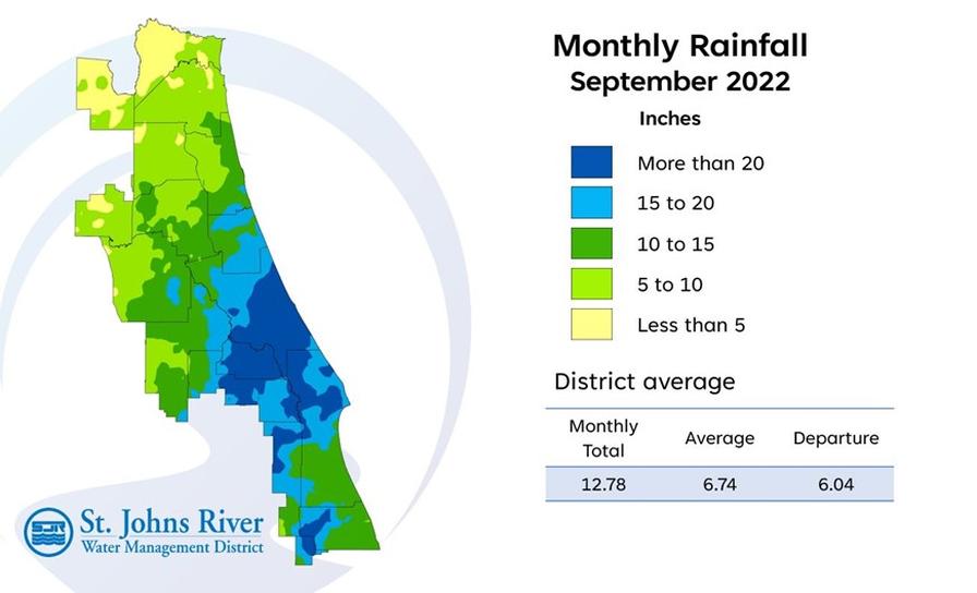
Districtwide, September rainfall averaged 12.78 inches, which is 6.04 inches above the average for the month. County-wide rainfall totals for the past 12 months ranged from a high of 72.3 inches in Seminole County to a low of 29.9 in Nassau County.
Three weeks after the hurricane, rivers and tributaries in the area remain high. Scores of properties and roadways are still under water, too.
The Atlantic hurricane season officially runs to Nov. 30.