


Wet Season off to a Sluggish Start for Some Parts of the Sunshine State
The wet season in Florida normally gets going in the latter part of May, marked by daily afternoon sea breeze collisions that produce precipitous storms. This year so far, the rain has been a little inconsistent through June.
According to the St. Johns River Water Management District (SJRWMD), recent rainfall this month throughout its 18-county region has relieved some parts of Northeast Florida that had been abnormally dry after below-average rainfall in June.
Indian River County in the southern reaches of the district was an exception in June, SJRWMD officials report, where for the first time in seven months the county received above-average rainfall, relieving near drought conditions.
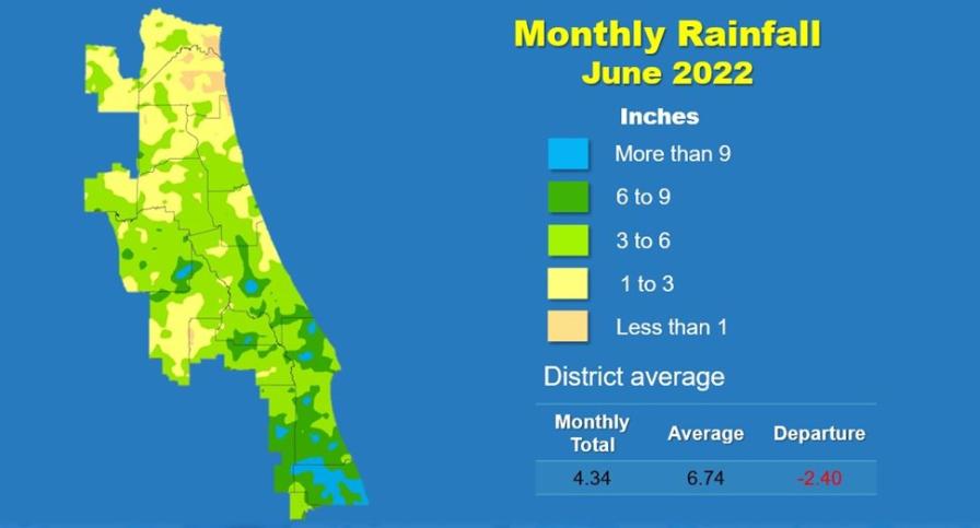
Graphic courtesy of SJRWMD
Other highlights from SJRWMD’s latest hydrological report include:
• Districtwide, June rainfall averaged 4.34 inches, which is 2.4 inches below the average for the month.
• Indian River County had the most rainfall, with a countywide average of 9 inches.
• Duval County received the least amount of rainfall at only 2.2 inches.
• Districtwide, the cumulative rainfall total for the past 12 months is 50.40 inches, which is 0.61 inches below the long-term average.
Despite three named tropical systems during June, none had any marked impact on rainfall around the SJRWMD or anywhere in Florida by and large. “Potential Tropical Cyclone One,” which eventually developed into Tropical Storm Alex once it crossed over South Florida into the Atlantic Ocean, provided decent rains in Miami-Dade and Monroe counties.
Updated Atlantic hurricane season forecasts continue to track what is likely to be another above-normal campaign. July is typically quiet in the Atlantic basin with activity picking in August and peaking in mid-September.