


Make More Money Through Strategic Farming
 March 21, 2011
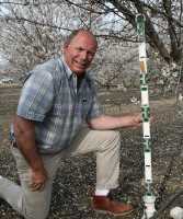
Consultants Matt Angell and Jim Yager believe the whole concept of precision agriculture has become far too complex. Because of that, the partners are on a mission to convince growers of all sorts, whether big or small, young or old, that they can make precision ag technologies work for them to grow better trees and vines.
Their new company, Strategic Farming, is based on a simple concept that they have boiled down to “M3.” The three Ms stand for Map, Measure, and Manage. They say any grower who utilizes this system, employing technology that is currently available, can increase their net profits.
Here’s a brief look at each step, using almond growing as an example, as Angell farms 100 acres of almonds — as well as 40 acres of winegrapes — in Madera, CA. Incidentally, he has only limited expansion plans, and says it’s because of precision farming. “We have a different model now that land is $10,000 or $15,000 an acre and resources are through the roof,” he says. “It’s better to farm 100 acres really, really well than to farm 200 acres just good.”
Mapping
Soils are fundamental to good farming practices. The variability of your ground determines the potential of your crop outcome, so mapping is vital. “It’s the ability to know where you’re standing in your field,” says Angell, “so that when you scout you have true knowledge.”
Strategic Farming was founded in 2009 by Matt Angell, Jim Yager, and Jim’s son, Aaron. Matt and Jim, who make their homes in California’s San Joaquin Valley, have extensive backgrounds in agriculture, both farming on their own and consulting other growers. Aaron, or “AJ,” is a high-tech publisher and lives in Austin, TX.
After graduating from Cal Poly-San Luis Obispo, Angell worked in a family cattle operation, and then took a job with Altamount Agrisystems, which was later acquired by John Deere. He met Yager, who has a Ph.D. in Agronomy from Kansas State University and worked for many years as a researcher for E.I. DuPont, in 1995. After installing thousands of acres of drip irrigation through the 1990s, Angell says it became obvious that growers needed a tool that would allow them to “see” what was happening in their crops and how water was being used by the plant. In 2003 he and Yager mapped, designed, and installed their first variable rate irrigation system. “It became an instant success and we knew this was going to be an important shift in irrigated agriculture,” he says.
Angell then discovered a software company called PureSense that had been developed at NASA Ames, a research and development center in Mountain View. The technology was originally developed in the wake of the 9-11 attacks for monitoring municipal water systems, with software that provided predictive analysis and alerting capabilities. Angell, along with the existing PureSense team, took the technology and built the PureSense agricultural application in 2004. Angell left the company in an amicable parting in 2009, and still frequents the PureSense offices in Fresno.
What’s next for the pair? Definitely smart phone apps, which means using The Cloud, on-demand computer network access from anywhere, strengthening the bond between agriculture and technology. “We want to see a convergence of California’s two great valleys,” he says, referring to the Silicon and the San Joaquin. “If they can, no one can stop us.”
It’s also critical that maps not just be two-dimensional, says Yager. They need to be three-dimensional in that you know what’s under the surface, that you know the soil’s electroconductivity through EC mapping, as well as its texture, through core sampling. “That’s why we map, so we know what’s out there, what is the cation exchange capacity of this block,” says Yager. “Once I map I know how to build my irrigation system.”
For example, through mapping Angell found some very sandy soil in his 100-acre block that had a lot less water-holding capacity. To avoid over-irrigating in that area he has increased the number of trees by 20%, going from 18-foot to 16-foot spacing. He will also be on the lookout for navel orangeworm (NOW) this summer as soft shell almonds will split earlier on sandy soils, says Yager. “If you want to see a NOW or mite flare-up, look at your sandy soils,” he says.
Measuring
Many growers have traditionally irrigated entire blocks uniformly. They talk to neighbors, then eyeball the land. “Then he’ll irrigate all the ground the same based on his sandiest ground,” says Angell, shaking his head. “He over-waters his best soils, he’s lowering his yields, and may be causing hull rot.”
This grower’s good, heavier soils might have had the potential to yield 3,400 pounds an acre, but he based his irrigation decision on the weaker soils, which only had a potential of 2,400 pounds per acre. “The crime is that he’s reducing the yield of his best ground,” says Angell, “and all he has to do is measure his soil moisture and gain an understanding of the soil variability of that block.”
On his farm, Angell employs soil moisture measuring devices from an Australian company, Sentek, that measure soil at varying depths, from 1 to 5 feet. Through constant measurement, he has an extremely accurate picture of what’s happening in his 100-acre block. “I would not have farmed unless I had this technology,” he says flatly. “I would have leased it out.”
Adds Yager: “There are some good (almond) farmers out there who could be making 20% more. And the more profit, the more sustainability.” Adds Angell: “The more net profit.” Yager nods.
Managing
Once the grower understands the soils and what he is going to measure, he can ask better questions about what’s going on in his fields. The farmer who was over-irrigating in the previous example is also going to push the nitrogen out of his active root zone because he doesn’t know the permeability of the soil. But if you know you have some sandy soils, and then you learn the permeability of those soils, you will be able to manage your irrigation effectively.
For example, says Yager, you might learn that the permeability of a certain block might be 1.5 inches per hour in the sandy areas, while it’s only 0.2 inches in the soil with high levels of clay. “Now I can manage it,” he says. “I increase the frequency of my fertigation on my sandy soils by spoon-feeding it — running the system once a day instead of twice a week.”
In many areas, Angell notes that irrigation frequency may not be managed because of water district policies. If that’s the case, one option is using a reservoir as long as more water is not lost to ground water seepage or evapotranspiration.
Managing doesn’t always call for the latest technology, Angell emphasizes, and irrigation is a good example. Those on all sides of the issue of sustainability pretty much agree that drip irrigation is generally good. It makes economic sense to use just the right amount of water — and fertilizer, if it’s a fertigation system — and the impact on the environment is generally reduced.
However, drip isn’t more environmentally friendly in some instances, says Angell. At the beginning of the growing season, it’s really important to start most tree fruit and nut orchards off with a full profile of water. To do that with drip would be time-consuming, but that’s not all. “It takes energy to pressurize a drip system,” he says, “and that increases your carbon footprint.”
In this instance, using the traditional flood irrigation to fill the soil profile, and then irrigating as needed through the season, is a much more environmentally — and economically — sound approach, making it more sustainable. “But you wouldn’t know unless you were measuring (the energy use), and then you’ve got to manage it,” he says. “Mapping, measuring, and managing allows you to grow crops the best you can using today’s technology.”
Subscribe Today For