Pre-Winter Weather Signals Farmers Should Know Now By Paul Rusnak|November 25, 2025 Unique take on long-range 2025-2026 winter weather forecast focuses on early season patterns growers should have on their radar. Read More
4 Fruit Varieties You Might Want To Add to Your Crop Portfolio By Growing Produce Staff|July 21, 2026
Video: Why Chasing High Prices Can Backfire on Vegetable Growers Posted by Growing Produce Staff|July 21, 2026
FDA Continues Focus on Lettuce in Cyclospora Outbreak Probe Posted by Growing Produce Staff|July 20, 2026
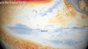
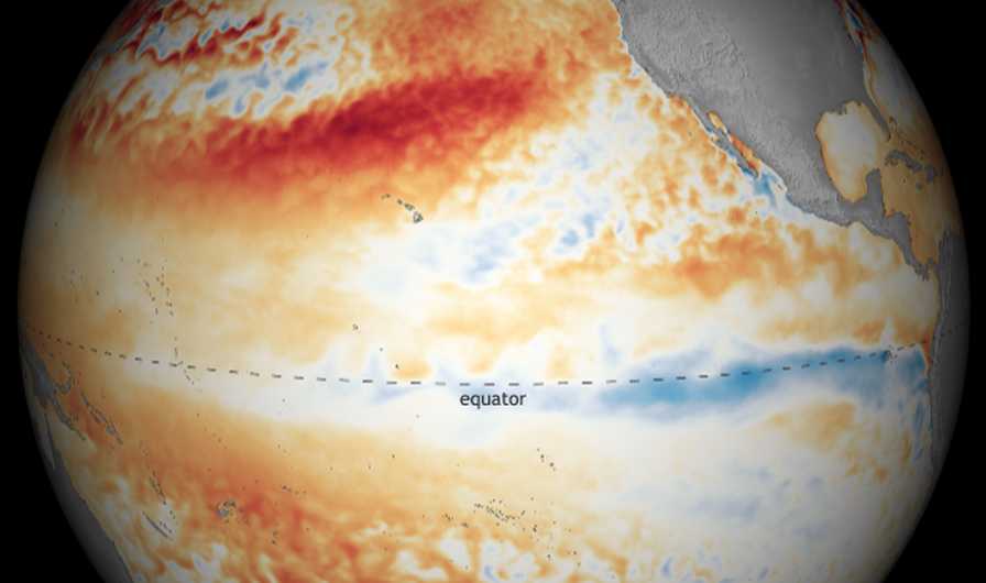
La Niña Looms Large in Official Winter 2024-2025 Outlook By Paul Rusnak|October 21, 2024 Returning climate pattern looks to bring warmer and drier conditions to the south and wetter conditions in the north, according to NOAA’s latest forecast.
What Will Winter 2024-2025 Look Like? Farmers’ Almanac Places Its Bets By Paul Rusnak|August 12, 2024 Editors of long-running publication factor La Niña into their ‘wet winter whirlwind’ predictions for the 2024-2025 season.
Texas Ag Assessing Damages in Wake of Hurricane Beryl By Paul Rusnak|July 9, 2024 Initial reports are coming in from the field after record-breaking storm makes its way to the Lone Star State with high winds and a wall of water.
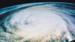
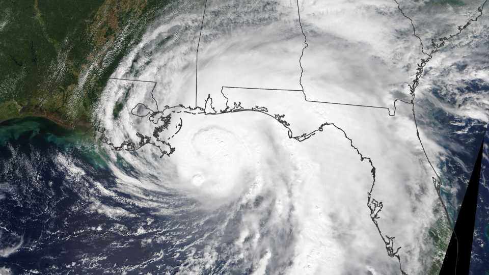
Powerful Predictions for the 2024 Atlantic Hurricane Season [Update] By Paul Rusnak|May 23, 2024 Early observations from climatology experts indicate what could be a record-breaking campaign in the tropics. So far, they’re on target.
Drought-Free Status for California Through 2025? Forecasters Think So By Paul Rusnak|March 5, 2024 Water supply in a surplus thanks to consecutive seasons of wild winter storms and atmospheric rivers.
La Niña Is Still in Control — What Does It Mean for Winter 2022-2023? Posted by Paul Rusnak|November 4, 2022 NOAA’s seasonal outlook is once again influenced by the unique climate pattern. Find out where it will be warmer and drier than average in the U.S.
Climate Conditions Go In for a Double Dip: Here Comes La Niña – Again!? Posted by Paul Rusnak|October 19, 2021 The tell-tale atmospheric phenomenon is setting up shop for the second winter in a row. Here’s what it might mean for weather across the U.S.
2020 Strikes Again! It’s a Full House of Weather Wild Cards By Paul Rusnak|September 16, 2020 The Northern Hemisphere just had its hottest summer on record. La Niña is officially here, too. Oh, and that’s just the tip of the iceberg.
The Watch Is on for La Niña! So, What Does It Mean? By Paul Rusnak|July 24, 2020 There’s an elevated chance for the climate phase to take over this fall. Learn more about what to expect.
Florida Dry Season Stuck in Rain Delay Posted by Paul Rusnak|February 14, 2018 La Niña, where art thou? Normal wintertime weather pattern taking a walk on the wet side in Sunshine State.
What NOAA is Expecting Winter 2018 to Look Like Posted by Paul Rusnak|October 23, 2017 Looming La Niña could mean colder and wetter than normal in the northern U.S. and drier than usual in the south.
Are You Feeling Befuddled By Fickle Forecasts? [Opinion] By Paul Rusnak|September 9, 2016 In any situation, proactivity pays. We can wait for the sky to fall, or we can sing in the rain.
Second Half Of Atlantic Hurricane Season Could Get Hairy Posted by Paul Rusnak|August 12, 2016 After a relatively sluggish start to the campaign, revised forecast foresees increased tropical activity ahead.
Move Over, El Niño, La Niña To Affect Fall Weather Posted by Christina Herrick|August 5, 2016 U.S. forecast calls for cool, wet conditions in the Northwest; drought to continue in West; warmth in the East; and stormy in the Southeast.


![Powerful Predictions for the 2024 Atlantic Hurricane Season [Update]](https://s3.amazonaws.com/files.growingproduce.com/growingproduce/wp-content/uploads/2023/09/NASA_satellite_view_Hurricane_Idalia-300x169.jpg)

![Are You Feeling Befuddled By Fickle Forecasts? [Opinion]](https://s3.amazonaws.com/files.growingproduce.com/growingproduce/wp-content/uploads/2016/09/hurricane_forecast_models-300x169.jpg)