


Potent Storm Season Rains Helping Pad Aquifer Levels in Florida
The wet season in Florida can be quite routine with the daily seabreeze collision that occurs every afternoon. Add to that a little extra juice from the tropics, and rainfall totals can pile up quickly.
July started with Tropical Storm Elsa making landfall on Florida’s northern Gulf Coast, bringing rainy conditions to parts of the St. Johns River Water Management District (SJRWMD).
The month wrapped up (not surprisingly) with above-average rainfall amounts reported across the 16-county District except for a small portion of its southernmost boundaries.
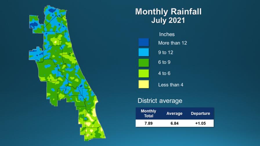
Graphic courtesy of SJRWMD
A report outlining hydrologic conditions was recently released by the SJRWMD’s governing board. Here are the stats for July:
-
- Districtwide, July rainfall averaged 7.89 inches, which is 1.05 inches above the long-term average for the month.
- Counties with the highest rainfall totals are Alachua, with 10.7 inches of rain, followed by Baker, Nassau, and Seminole counties, which all received between nine and 10 inches.
- The county with the least rainfall in July was Indian River, with 5.4 inches. Portions of southern Brevard were also drier.
- Districtwide, the cumulative rainfall total for the past 12 months is 53.65 inches, which is 2.64 inches above the long-term average.
- Countywide rainfall totals for the past 12 months range from a high of 59.25 inches in Alachua County to a low of 48 inches in Osceola County.
- Upper Floridan aquifer conditions at the end of July were mostly in the normal range, but a large zone of high levels was recorded along the western side of the District and in southern Volusia/northern Brevard counties. In many monitoring wells used for the monthly report, water levels increased more than 10 percentile points in July.
Rainfall trends in August are continuing along the same path as July so far. Tropical Storm Fred, which made landfall in the Panhandle on Aug. 16, dumped buckets of rain that stretched across the peninsula. Minor flooding, some surge, as well as downed trees and power lines were reported near the point of impact.
Check out some of the video feed tweets from Mike Boylan (creator of the popular online weather portal Mike’s Weather Page) who was on site as Fred made its pass.
East of Port St. Joe. pic.twitter.com/2Nr1kiYxTu
— Mike's Weather Page (@tropicalupdate) August 16, 2021
East of Port St. Joe. pic.twitter.com/OhYz9bNKtO
— Mike's Weather Page (@tropicalupdate) August 16, 2021
Trying to drive through one of Fred's bands near Perry, FL. Blinding! pic.twitter.com/DRKKqZSwGf
— Mike's Weather Page (@tropicalupdate) August 17, 2021
More of this kind of weather action is still to come. Gotta keep in mind, the historic peak of Atlantic hurricane season is still about a month away.