Weather Woah! What a Difference a Half Year Makes for California Growers
 May 9, 2023
 Last year at about this time, more than 400 people packed an auditorium in California’s San Joaquin Valley to demand action on sourcing more water for the valley’s parched farms. After a few years of drought, and new limits to groundwater pumping, some in the audience were talking about the prospect of fallowing prime farmland. Worse, if growers couldn’t demonstrate a reliable source of water, the bankers in the audience said they likely wouldn’t get any loans, the beginning of the end for some operations. The hot and sunny days were dark indeed.
Flash forward a year, and things look very different. California has been pounded by a series of storms produced by atmospheric rivers. Aptly named, these are long, narrow ribbons of water vapor that travel from the tropics — hence the moniker “Pineapple Express” — and drench much of California before slamming into the Sierra Nevadas producing copious amounts of snow.
How much? Lake Tahoe has received more snowfall than in any other season — or at least any season since 1971-1972, the earliest year for which the University of California, Berkeley Central Sierra Snow Lab on Donner Summit has daily measurements. As of March 6, the Snow Lab had measured 580 inches, or just over 48 feet, of snow since Oct. 1.
The mountain snowpack, which normally contains about one-third of the state’s water storage, is at levels not seen in years. In March, the average snowpack level statewide was at 227%. In the Southern Sierra Range, a main feeder for both the Central Valley and the Los Angeles area, levels were approaching 300%, with snowpack at 283%.
Generally, if the snowpack is 100% of normal on April 1, the state is considered to have enough water for its three consumers in the coming year: agriculture, urban, and the environment. So it’s safe to say the state is no longer facing drought.
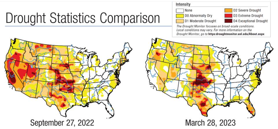
These two maps show what drought stage is faced in different parts of the country: the darker the color, the more severe the drought. That big dark blob in California on the map for last September covers much of the San Joaquin Valley, some of the world’s most productive farmland, and an area that produces nearly all of the major U.S. tree nuts, as well as most of the U.S. stone fruit and grapes.
Source: The U.S. Drought Monitor is jointly produced by the National Drought Mitigation Center at the University of Nebraska-Lincoln, the United States Department of Agriculture, and the National Oceanic and Atmospheric Administration. Map courtesy of NDMC.
California is not the only prominent agricultural state to see changes in the past six months. Interestingly, another powerhouse, Florida, has gone in the opposite direction. While California’s dark blob on the map from Sept. 27, 2022 was essentially erased by the rains, the entire state of Florida is now experiencing at least mild drought. Dry weather continued this spring in the Sunshine State, especially in parts of the Florida Peninsula, where severe drought coverage increased in several areas.
Texas too has seen its drought areas worsen slightly in the past six months.
On the bright side, New England was facing a mild drought six months ago, but that has now been erased. More severe droughts in western states where there is little farming, such as Nevada and Utah, also saw their severe droughts ameliorated this past winter by the storms of the “Pineapple Express.”
Subscribe Today For