


Extreme Weather Watch: Is Super El Niño on the Way?
There’s no doubt you’ve heard of El Niño and La Niña. But what about a “Super El Niño”?
The opposing climate phase siblings (El Niño and La Niña) get bantered about every year when it comes to predicting global temperature, precipitation, and tropical activity for a given season. NOAA notes, “the pattern shifts back and forth irregularly every two to seven years, bringing predictable changes in ocean temperature and disrupting the normal wind and rainfall patterns across the tropics.”
This year is shaping up differently though. Scientists are warning that a Super El Niño might be in the making. This could mean even bigger extremes in weather that could affect millions of people and impact livelihoods like agriculture.
AgroClimate, which references the International Research Institute for Climate and Society, says there is a 92% chance El Niño will be the prevailing climate phase for the next three months. NOAA scientists believe this could be the case all the way through February 2027.
NOAA’s Climate Prediction Center (CPC) tracked El Niño Southern Oscillation (ENSO)-neutral conditions through mid-May. But sea surface temperature anomalies have increased across the central and eastern Pacific Ocean during the spring. This is a tell-tale sign of El Niño emergence.
CPC’s forecast indicates sea surface temperatures increasing through the summer and reaching +1.5°C (strong El Niño threshold) by the September-October-November window. “By the late fall and early winter (October-November-December), there is near a 2 in 3 chance of a strong El Niño.”
The last El Niño was 2023 going into early 2024. It was considered a moderate event. More than a few produce growers in California could argue 2023 was strong based on several extreme weather events that rocked the region. The last “strong” El Niño occurred 2015 going into spring 2016. Before that, 1997-1998 set the bar for strong El Niño events.
So, what does all this mean for now? NOAA’s June-July-August Temperature and Precipitation Outlooks were recently released. Check out the graphics below to see which parts of the U.S. are likely to see extremes.
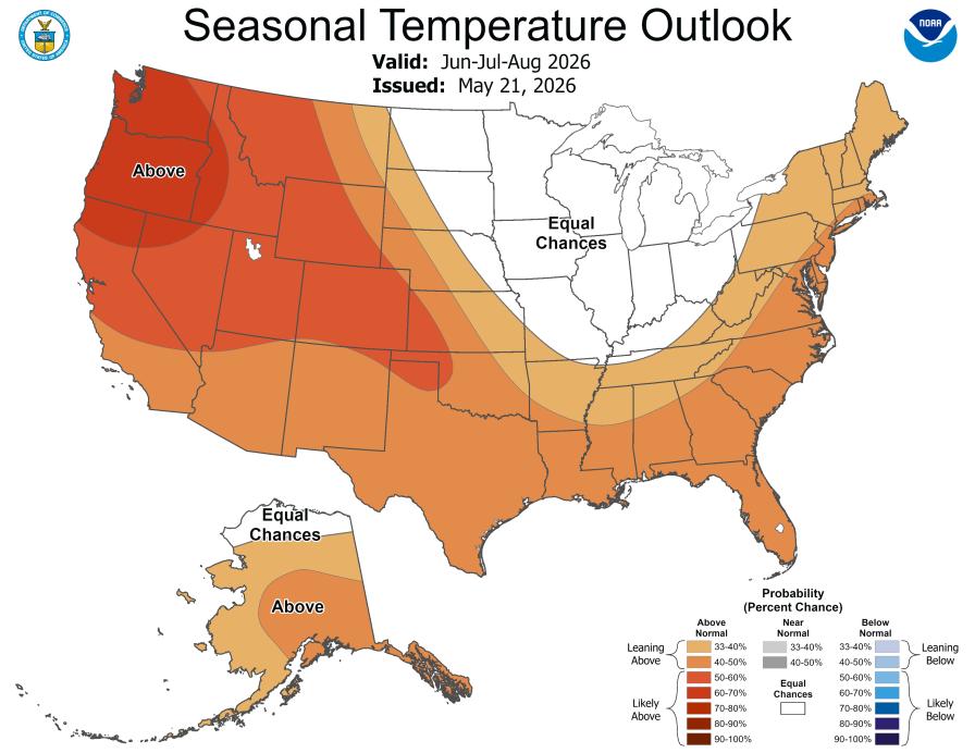
Image: NOAA
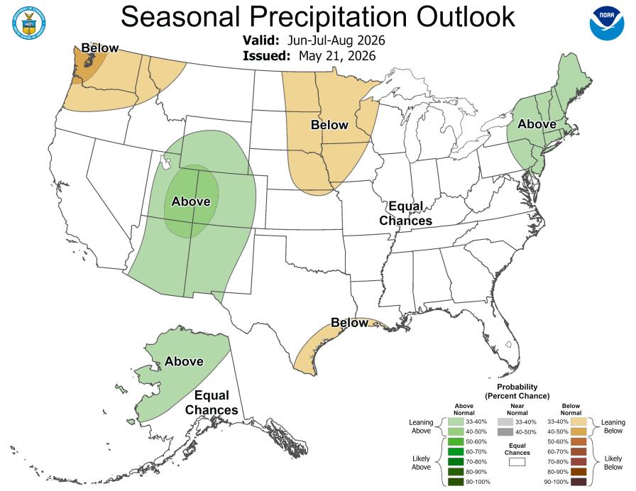
Image: NOAA
NOAA issues updated 90-day outlooks every month. The next update (July-August-September) is scheduled to be released on June 18.
El Niño and What It Could Mean for Hurricane Season
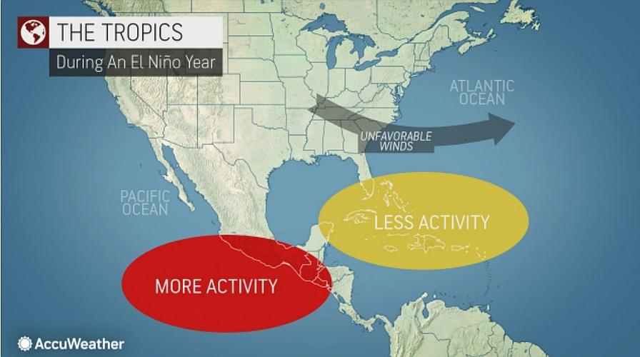
Early predictions for the 2026 Atlantic hurricane season are for a slightly-below average campaign. Why? El Niño.
An El Niño event normally means less tropical activity in the Atlantic basin due to less conducive conditions, including wind shear. This upper-air occurrence tears apart developing storms.
Colorado State University Climatologist Phil Klotzbach is closely monitoring the potential for a moderate to strong El Niño for the peak of hurricane season. “Sea surface temperatures in the western tropical Atlantic are warmer than normal but slightly cooler than normal in the eastern and central tropical Atlantic,” he notes in the CSU hurricane season forecast summary. “We anticipate El Niño being the dominant factor for the upcoming hurricane season, driving increased levels of tropical Atlantic vertical wind shear.”
Despite El Niño being associated with less active hurricane seasons, storms have found a way to defy the odds. For example: The 2023 hurricane season was an El Niño year and yet it finished as the fourth most active season since recordkeeping. And during that season, major Hurricane Idalia struck Florida’s Big Bend area causing significant flood and wind damage.
RELATED CONTENT: 8 Pointers To Prepare Your Farm Now for a Hurricane
Other notable hurricanes that made an impact during El Niño years: Florence and Michael (2018); as well as four hurricanes that crisscrossed Florida in six weeks during the 2004 season (Charley, Frances, Ivan, and Jeanne). However, not all El Niño events are created equal.
I reached out to Ryan Truchelut, President/Chief Meteorologist of WeatherTiger LLC based in Tallahassee, FL, for his take on the current situation. I asked him what other influential environmental factors and patterns he looks at — besides climate phase — to help determine how active and impactful a hurricane season could be.
“A hurricane season cannot be reduced to a single metric, El Niño/ENSO or anything else,” Truchelut says. “Atlantic water temperature anomalies in a horseshoe from the Caribbean to West Africa and north toward southwest Europe are predictive at this stage as well– warmth there in early summer presages not just more fuel for hurricanes in the August to October peak of the season, but better moisture and shear conditions in the Main Development Region as well.”
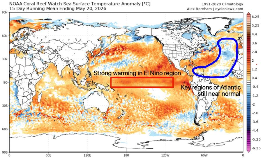
Here is a snapshot at global sea surface temperature anomalies as of late May 2026. Note the highlighted areas to watch.
Original graphic: Alex Boreham, CyclonicWx.com; mark-up by Ryan Truchelut, WeatherTiger LLC
The continuous fluctuation of many factors is what makes forecasting this tumultuous season from year to year a challenge. You can’t just turn your back after the first forecast. It’s a constant work in progress.
“Overall, landfall risk is a function of overall activity, development location, and storm motion (steering), only the first of which can be anticipated with much skill,” Truchelut adds. “While activity is most dependent on more slowly changing ocean temperature anomalies, the latter two are more weather-dependent, and thus can vary dramatically within a season on scales of days to weeks. That’s why I’m emphasizing that a lower risk season, which I believe 2026 will be, is not a zero risk season.”
There’s a passage that stands out to me in WeatherTiger’s 2026 Atlantic hurricane seasonal forecast issued a few weeks ago. I believe it sums up the finicky nature of trying to predict hurricane season activity based solely on historical climate phase data. “Like a fast-food drive-thru, climate is what you order, but weather is what is actually in the bag.”
The Atlantic hurricane season officially begins June 1 and runs through Nov. 30.
Stay tuned. Weather is always changing. That’s why we watch.
Subscribe Today For